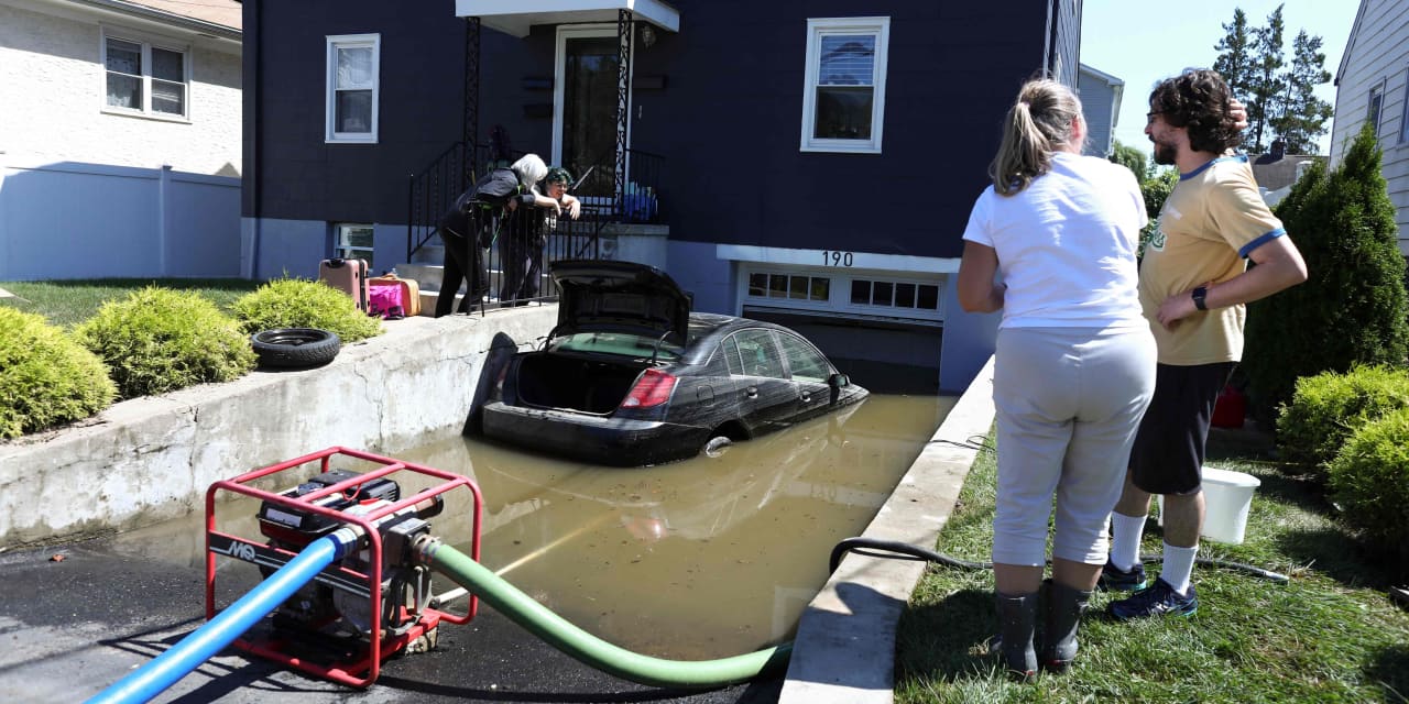
As remnants of Hurricane Ida passed over the mid-Atlantic region Wednesday, they unleashed a deluge of record-breaking rain.
For the first time ever the National Weather Service had to issue a “flash flood emergency” warning across New York’s five boroughs as water quickly accumulated across the region, turning subway steps into waterfalls and highways into rivers. More than 40 people died across the East Coast as a result of the storm system, including at least 13 people in New York City alone.
The situation became a test of the efforts to better calculate the flood risk in the Big Apple and beyond following the devastation wrought by Superstorm Sandy nearly a decade ago. In response to the ravages of Superstorm Sandy, then-Mayor Michael Bloomberg commissioned a study by the Rand Corporation to zero-in on the rising costs of flood insurance in a city that was being forced to reckon with a future of increased flooding events.
That study, which was completed in late 2013, found that the average cost of flood insurance in a flood zone had grown from less than $500 a year to as much as $30,000. At the time, many insurers also began to raise the cost of insuring homes in New York City flood zones and in some cases ceased covering them entirely.
The situation and future projections were so dire that entire neighborhoods on coastal Staten Island took advantage of a New York State program to sell their homes and move elsewhere, allowing the state to turn the land into unpopulated flood protections zones, rather than pay the costs of rebuilding over and over.
Earlier in 2013, the Bloomberg administration released the findings of its major research project into how to prepare the city and its homeowners for the coming storms, a report that included proposals to initiate major offshore infrastructure projects and redraw the city’s flood zone map, which had not been updated since 1983.
That update added roughly 68,000 existing buildings to flood zones, requiring property owners to face soaring premiums by adding flood insurance to existing plans if they could find coverage at all.
The city also concluded in 2013 that the effects of climate change would cause more than 114,000 structures to be added to that category by the year 2050.
Nevertheless, newer flood zone maps for the five boroughs, the most recent being a 2015 preliminary FEMA map, did not include many of the inland areas that found themselves underwater thanks to Ida’s pounding from above. And property owners, many of whom were likely caught off-guard by the sheer possibility of such a storm, will be left footing the bill.
How flood maps are drawn — and fall short
The flood maps drawn by FEMA represent the government’s official determination of an area’s disaster risk. Even still, the process and information used to produce the maps mean that many areas that still feature a high risk of flooding are left out of the top flood zones.
“While the government does create these flood maps with input from communities and property owners, they are simply a guide,” said Scott Holeman, media relations director at the Insurance Information Institute, an industry trade group.
“As we see population shift and climate change occurring there is more risk for exposure,” he added.
FEMA develops the maps in concert with state, local and tribal officials. Periodically maps are redrawn based on changing conditions, population growth and when scientific advancements are made. A range of data related to water flow, infrastructure and land use are used, along with existing maps of floodplains when possible to develop the new flood maps. (FEMA did not return a request for comment.)
After a preliminary map is drawn, it is presented to stakeholders and the public through an open house, where residents can appeal and comment on it. Communities must then vote to adopt the final map after it is revised.
One of the primary uses for FEMA’s maps is to designate in what areas homeowners with certain mortgage must purchase flood insurance. There are multiple types of flood zones, labeled with letters. A and V zones are the most at-risk regions, where this insurance is required. A zones cover areas near lakes, rivers, streams or other bodies of water, while V zones cover beachfront locations. Comparatively, Zones C and X are located outside of the 500-year floodplains and have minimal flooding risk, while D zones are areas that have yet to be analyzed by FEMA.
“ Research suggests that FEMA is overlooking as much as 70% of flooding risk across the country. ”
Even with all these distinctions, FEMA misses a significant degree of flood risk, research shows. Studies from First Street Foundation, a nonprofit that examines climate risk to properties, found that there are around 70% more properties that are at risk of experiencing an extreme flood event than FEMA has within its flood zones.
“This is not necessarily FEMA’s fault,” said Michael Lopes, communications director at First Street Foundation. “They operate within a lot of bureaucratic and regulatory red tape. What they are and are not allowed to consider as inputs into their model is mostly dictated by Congress.”
A major reason why FEMA uncovers fewer properties at risk of flooding than First Street does is due to data pertaining to climate change. First Street incorporates information from the Intergovernmental Panel on Climate Change related to carbon emissions into its modeling.
FEMA’s model is also more concerned with the potential for storm surge and sea level rise, whereas First Street factors in more considerations related to heavy rainfall.
“Every time they redraw a map, they’re redrawing it to today’s specifications — they’re looking at the recent past and the impact of climate change on flood risk to this point,” Lopes said.
“But if you’re not projecting forward and saying ‘This is what we think it’s going to look like,’ there’s just going to be a lot of risk that’s out there that you’re not you’re not going to pick up,” he added.
Property values don’t reflect the likelihood of disasters
Despite the serious — and growing — risks that flooding presents across the country, development continues to occur in particularly threatened areas including in historic floodplains and beachfront locales. That has expanded the losses from major disasters such as hurricanes.
Making matters worse, property values have not priced in the risks associated with flooding. “Flood risk is generally not fully priced into the values of homes,” said George Ratiu, manager of economic research at Realtor.com. “By some measures, homes located in floodplains may be overvalued to the tune of $44 billion.”
This has created a situation where there is a divide between property prices and insurance rates. One inch of floodwater can cause as much as $25,000 in damage to a home, yet people in the most threatened parts of the country will pay the most for insurance. “The bottom line is that if you live in a flood zone, you are going to pay more for your home insurance,” said Gareth Hedges, director of P&C Operations at Policygenius, a website where consumers can compare insurance rates. Compounding the situation is the fact that in some cases insurance companies have exited markets due to the heightened flood risks, leaving homeowners with little ability to shop around for lower rates.
“ ‘By some measures, homes located in floodplains may be overvalued to the tune of $44 billion.’ ”
Climate-change deniers may have contributed to this conundrum, and may be propping up property prices in many parts of the country. But there are signs that this is beginning to change. A 2020 study from Realtor.com, which used data from First Street Foundation on flood risk, found that sales prices in high-risk areas had only risen 25% over the past five years, which was as much as 5% lower than homes in low-risk areas.
Misconceptions abound regarding the risk of flooding
One reason why the risk of flooding isn’t being properly priced into real-estate markets is that the U.S. public may be underestimating how much risk there really is.
Some 74% of adults believed they weren’t at risk for flooding, according to a survey conducted in 2020 by Harris Poll for flood insurance provider National Flood Services. And numerous studies have shown that gaps in flood insurance coverage abound, even though homeowners with federally-backed mortgages are required to carry flood insurance if they live in a designated flood zone.
“A majority of homes across the country do not carry it,” Ratiu said.
“ ‘What was one a one-in-100-year storm might now be something like a one-in-200-year storm in terms of intensity.’ ”
The way officials describe catastrophic events like Wednesday’s flooding in New York and New Jersey may not be helping matters. Multiple news reports described it as a “100-year storm” or a “once-in-a-century flood,” but these labels are misleading.
“To most people, that sounds like something that only happens once every 100 years,” Lopes said. In reality, a 100-year storm is referring the probability of such a storm happening. It means that there’s a 1% chance of a storm of that intensity happening in any given year — and not that once it happens the area won’t see another storm like it for another 99 years.
“They’re becoming more frequent and more intense, so what was one a one-in-100-year storm might now be something like a one-in-200-year storm in terms of intensity,” Lopes said. “What constitutes a one-in-100-year storm is literally changing with the climate around us.”
Part of the problem may also be that many Americans incorrectly believe that they are protected against the financial repercussions of these flooding events. A recent study from insurance marketplace Policygenius found that 53% of homeowners didn’t realize that flood damage isn’t covered under a standard homeowner’s insurance policy.
How homeowners can gauge their risk
Homeowners will need to go a step further than simply looking at FEMA flood maps to get a sense of the inherent risk of flooding to their property, experts said.
“If you happen to live within those zones, you’re going to be told you have flood risk,” Lopes said. “If you’re across the street, right now, you’ll be told you don’t, or at least you will have no way of knowing if you do — and that’s what the fundamental problem is.”
First Street makes its data readily available to homeowners through a platform called Flood Factor. Using the free online tool, a homeowner can get a sense of their current flood risk and how that risk will change over time based on developments and climate change. The platform will also show the extent of flooding from recent disasters, which people can use to get a more concrete sense of how bad flooding could be in their area. This information has been integrated into multiple real-estate platforms thus far, including Redfin RDFN,
(Realtor.com is operated by News Corp subsidiary Move Inc., and MarketWatch is a unit of Dow Jones, which is also owned by News Corp.)
Beyond using a tool like Flood Factor, there are practical questions homeowners can answer for themselves to think through the risk they’re facing.
“You may not live in a floodplain or a flood zone, but do you live near a body of water?” Holeman said. “Do you live at the bottom of the hill in your neighborhood? Do you have a basement?”
Ultimately, insurance experts recommend that every homeowners gets flood insurance, no matter where they live, given the remote possibility of catastrophe. Lopes, who lives in New York’s Westchester County, which took a major hit from the storms this week, noted that his home’s sump pump was running for more than 12 hours amid and after the storm to prevent basement flooding — even though his home is located at a high elevation.
“My street is badly flooded,” Lopes said. “There’s no water in my house but that’s just pure luck. And I am well outside of a FEMA-designated special flood hazard area.”


