Hurricane Sally, a plodding but powerful storm with winds of 85 mph, crept toward the northern Gulf Coast early Tuesday, with forecasters warning of potentially deadly storm surges, flash floods spurred by up to 2 feet (.61 meters) of rain and the possibility of tornadoes.
Hurricane warnings have been replaced by a tropical storm warning from the Mouth of the Pearl River westward to Grand Isle, Louisiana, including in New Orleans, the National Hurricane Center said. A tropical storm warning west of Grand Isle has been discontinued.
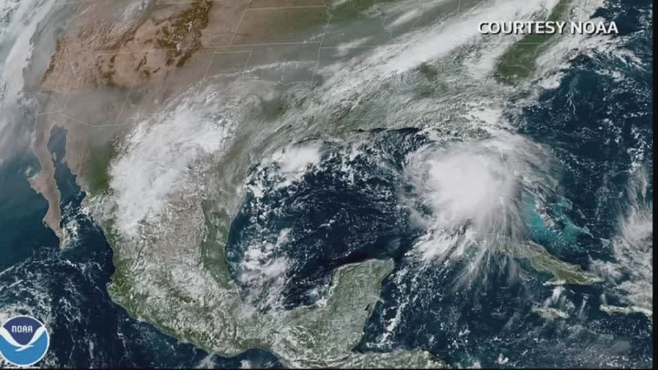
Hurricane warnings had stretched from Grand Isle to Navarre, Florida, but forecasters — while stressing “significant” uncertainty — kept nudging the predicted track to the east.
That eased fears in New Orleans, which once was in the storm’s crosshairs. But it prompted Florida Gov. Ron DeSantis to declare an emergency in the Panhandle’s westernmost counties, which were being pummeled by rain from Sally’s outer bands early Tuesday. The threat of heavy rain and storm surge was exacerbated by the storm’s slow movement.
President Donald Trump issued emergency declarations for parts of Louisiana, Mississippi and Alabama on Monday, and on Twitter urged residents to listen to state and local leaders.
Alabama Gov. Kay Ivey sought the presidential declaration after the National Weather Service in Mobile, Alabama, warned of the increasing likelihood of “dangerous and potentially historic flooding,” with waters rising as much as 9 feet (2.7 meters) above ground in parts of the Mobile metro area.
It all seemed a distant threat Monday afternoon in Waveland, Mississippi, as a shirtless, barefooted Trevor Claunch, of nearby Bay St. Louis, got in some last-minute beach time. But there were signs of trouble coming. Claunch marveled at how the Gulf waters had already crept over swaths of sandy shore and infiltrated bike paths and parking lots.
“Without any rain, and it’s already all the way up — I honestly want to stick around and see where it goes,” said Claunch.
But he wasn’t taking any chances.
“We’re going to go inland,” he said.
Others were taking the storm seriously as well, despite sunny skies. Coastal casinos shut down under orders from the Mississippi Gaming Commission. Meanwhile, motorists filled a convenience store parking lot in Ocean Springs, Mississippi, as they topped off gas tanks and stocked up on ice, beer and snacks.
“It’s second nature to us. It would have already been done but I had to work,” Zale Stratakos said as she helped her mother, Kimberly Stratakos, fill three plastic gasoline cans.
Sally achieved hurricane strength Monday and quickly intensified to a Category 2 storm with 100 mph (161 kph) winds. By early Tuesday morning, the storm’s maximum sustained winds had decreased to 90 mph (145 kph), making it a Category 1 storm. Wind speeds dwindled even further to 85 miles per hour (137 kph) by 5 a.m. EST but forecasters say some restrengthening is expected to occur late Tuesday.
The storm was located 115 miles (185 kilometers) south-southeast of Biloxi, Mississippi, and 60 miles (97 kilometers) east-southeast of the mouth of the Mississippi River moving at only 2 miles per hour (4 kph).
Forecasters expect the storm to turn northward Tuesday afternoon, and travel slowly north-northeastward from Tuesday night through Wednesday. The National Hurricane Center said early Tuesday the center of the hurricane would be moving near the coast of southeastern Louisiana later in the day.
Forecasters expect winds to increase to up to 110 mph (177 kph) over the warm Gulf waters before the storm blows ashore. On the current track, the storm is forecast to reach land near the Alabama-Mississippi state line by late Tuesday or early Wednesday.
The threat to Louisiana appeared to be easing, but flood control authorities remained on guard, closing gates along networks of waterways that could be pushed over their banks by the possible surge from the Gulf.
The southwestern part of the state was pummeled by Hurricane Laura on Aug. 27 and an estimated 2,000 evacuees from that storm were sheltered in New Orleans, mostly in hotels.
Monday marked only the second time on record, forecasters said, that five tropical cyclones swirled simultaneously in the Atlantic basin. The last time that happened was in 1971. None of the others were expected to threaten the U.S. this week, if at all, and one was downgraded to a low-pressure trough Monday evening.
The extraordinarily busy hurricane season — like the catastrophic wildfire season on the West Coast — has focused attention on the role of climate change.
Scientists say global warming is making the strongest of hurricanes, those with wind speeds of 110 mph or more, even stronger. Also, warmer air holds more moisture, making storms rainier, and rising seas from global warming make storm surges higher and more damaging.
In addition, scientists have been seeing tropical storms and hurricanes slow down once they hit the United States by about 17% since 1900, and that gives them the opportunity to unload more rain over one place, as 2017’s Hurricane Harvey did in Houston.


